This page consists of a bibliography and references sources on railroads in Idaho.
- Idaho
- Railroad Stations
- Electric Railroads and Trolleys
- Maps
- Books
- Videos, Newspapers, and Magazines

IDAHO
- Rail Safety, Idaho Public Utilities Commission
- Freight in Idaho, Idaho Transportation Department
ONLINE
- Boise and Interurban Railway photos (PDF). – Images from the Boise Public Library clipping files.
- Idaho Railroads and Railfanning in “The Gem State”. American-Rails.com – This railroad history site created by a railroad enthusiast provides good introductory information about railroads. It includes a list of works cited. https://www.american-rails.com/resources.html. Accessed February 9, 2019.
- Union Pacific – Includes Car Types, Glossaries, and Maps of the Union Pacific.
- Rand McNally Indexed Pocket Map Tourists’ and Shippers’ Guide: Railroads, electric lines, post offices, express, telegraph and mail service; counties, congressional townships, cities, towns, villages, rivers, lakes, islands, creeks, mountains, etc.; air service landing fields; population according to the latest official census; main highways. Booklet. Chicago, Illinois; New York, N.Y.: Rand McNally & Company, 1921. (PDF).
RAILWAY TIMETABLES
- National Association of Timetable Collectors http://www.naotc.org/
- Museum of Railway Timetables http://www.timetables.org/ – This site provides a virtual exhibit of Amtrak railway timetables.
- Union Pacific Railroad system employee timetables. Cheyenne, Wyoming: Union Pacific Historical Society, 2000.
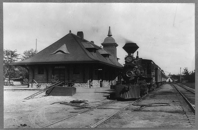
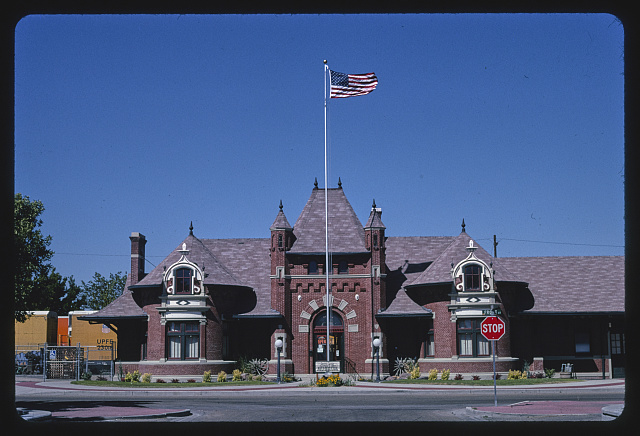
RAILROAD STATIONS
- Railroad Stations Historical Society (RSHS)
- Surviving Idaho Railroad Stations (PDF, date unknown) https://www.american-rails.com/support-files/idaho-railroad-stations.pdf
ELECTRIC RAILWAYS AND TROLLEYS
- Boise and Interurban Railway photos (PDF). – Images from the Boise Public Library clipping files.
- Bird, Annie Laurie. My home town. Caldwell, Idaho: Caxton Printers, 1968.
- Bauer, Barbara Perry, and Elizabeth Jacox. Treasure Valley’s electric railway. Charleston, SC: Arcadia Pub, 2013.
- Carter, Clive. Inland Empire electric line: Spokane to Coeur d’Alene and the Palouse. Coeur d’Alene, Idaho (P.O. Box 812, Coeur d’Alene, Idaho 83816-0812): Museum of North Idaho, 2009.
- Casner, Nicholas, and Valeri Kiesig. Trolley: Boise Valley’s electric road, 1891-1928. Boise, Idaho: Black Canyon Communications, 2002.
- Hilton, George W., and John F. Due. The electric interurban railways in America. Stanford, California: Stanford University Press, 2000.
- City of Eagle. Eagle. Charleston, S.C.: Arcadia Pub., 2012.
- Duran, James David, for the Central Bench Neighborhood Association; edited by Shari Hennefer and Boise City Department of Arts & History staff, Kathleen M. Lacey. Central Bench history. Boise, Idaho: Boise City Department of Arts & History, 2016.
RAILROADS CONVERTED TO TRAILS
- Bartley, Natalie L. Best rail trails. Pacific Northwest: more than 60 rail trails in Washington, Oregon, and Idaho. Guilford, Connecticut: FalconGuides, 2015. Second edition.
- Idaho Rails to Trials, VisitIdaho.org
- Existing Rails to Trails Conversions in Idaho as of August 2017 (PDF), Idaho Transportation Department
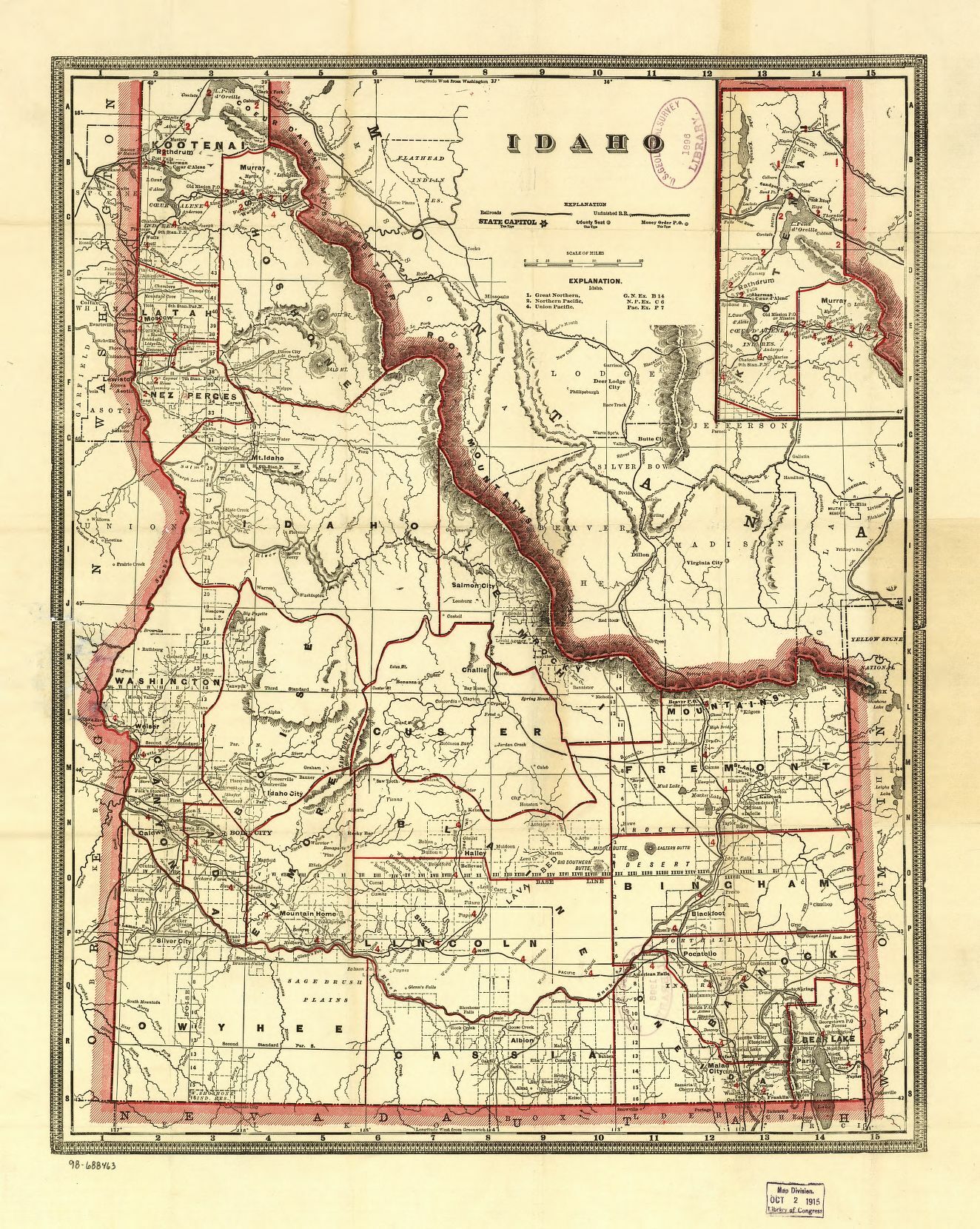
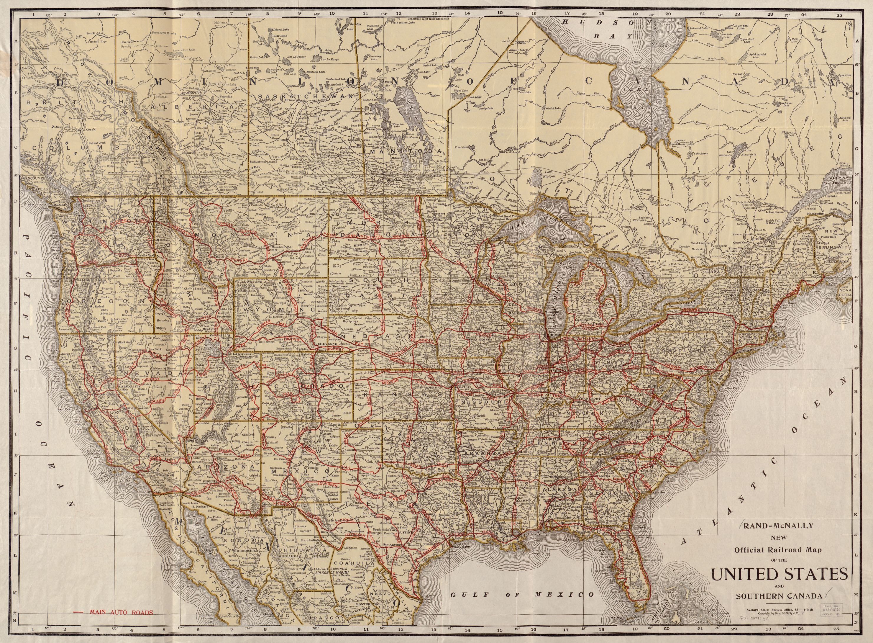
MAPS
- Idaho ghost towns, then and now: early towns, military roads, stage stations, early forts, overlay of modern road system. Map, Printed Cartographic Material, Cartographic Material. Scales differ (W 117p0s15–W 111p0s00/N 49p0s00–N 42p0s00). [S.n.]: R.N./M.L. Preston, 2000.
- Intermountain Map Company. Map of southern Idaho, 1919. Map, Scale [1:887,040]. 1 in. = 14 miles. Boise, Idaho: Intermountain Map Co., 1919.
- Library of Congress; compiled by Andrew M. Modelski. Geography and Map Division. Railroad maps of the United States: a selective annotated bibliography of original 19th-century maps in the Geography and Map Division of the Library of Congress. Washington: The Library: For sale by the Superintendent of Documents, U.S. Government Publishing Office, 1975. https://archive.org/details/railroadmapsofun00libr. Accessed January 7, 2019.
- Rand McNally and Company. Idaho. Map, Scale not given. Chicago: Rand McNally & Co., 1920? – “Numbers show rail mileage between towns regardless of the topography of localities.” Page from 1921 or 1923 edition of Rand McNally & Company’s Commercial atlas of America.
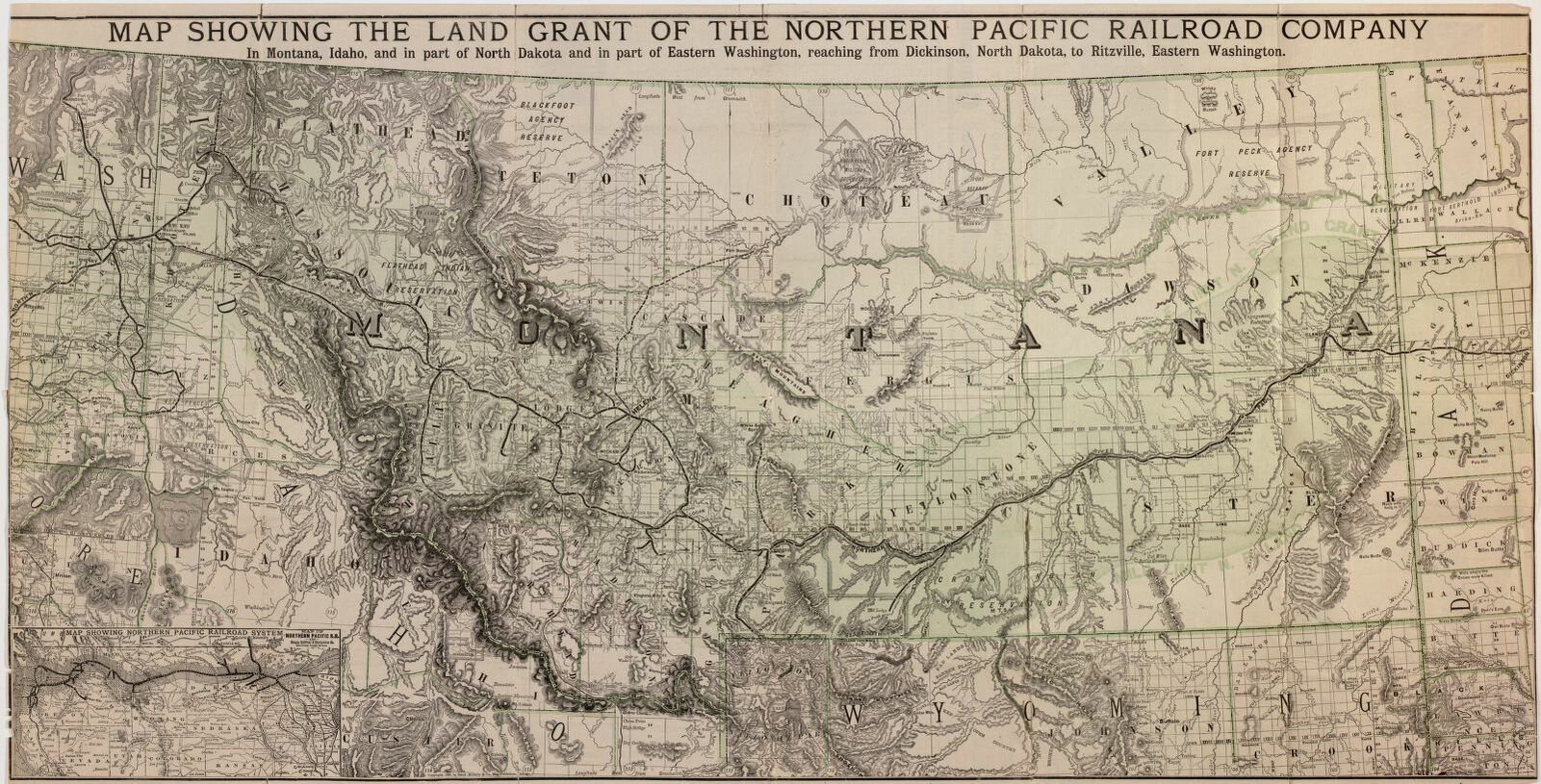
- Rand McNally and Company. Map of the Northern Pacific Railroad, its branches & allied lines. Map, Printed Cartographic Material, Cartographic Material. Scale not given. Chicago: Rand McNally, 1892.
- Rand McNally and Company. Rand McNally standard map of Idaho. Map, Scale [1:1,256,200]. 1 in. = 20 miles. Chicago: Rand McNally & Co., between 1919 and 1927.
- Smith, J.L. Railroad Map of The United States. Map, Scale 1:4,500,000. Chicago and New York: Rand, McNally & Co., Map Publishers and Engravers, 1889. David Rumsey Historic Map Collection. https://www.davidrumsey.com/luna/servlet/detail/RUMSEY~8~1~229112~5507967:Railroad-Map-Of-The-United-States. Accessed February 7, 2019.
- U.S. Geological Survey compiled and printed by the U.S. Geological Survey for the Public Roads Administration; subsequent revisions by the Public Roads Administration. Idaho transportation map: highways, railroads, canals, air lanes, and dredged channels. Map, Scale 1:250,000. Approx. 1 in. to 4 miles; Lambert conformal conic projection, standard parallels 33° and 45° (W 117°15ʹ–W 111°00ʹ/N 49°00ʹ–N 42°00ʹ). Washington, D.C.: Federal Works Agency, Public Roads Administration, 1945. Revised Edition.
- USGS Topographic Maps. Various years. Available online at in the USGS Topo Viewer https://ngmdb.usgs.gov/topoview/viewer/
BOOKS
- Abdill, George B. Rails West. Seattle, Washington: Superior Pub. Co., 1960. 1st Edition.
- Athearn, Robert G. Union Pacific country. Chicago: Rand McNally, 1971.
- Beach, Philip F. Wheat Country Railroad: The Northern Pacific’s Spokane & Palouse and Competitors. Pullman, Washington: Washington State University Press, 2018.
- Beal, Merrill D. Intermountain railroads: standard and narrow gauge. Caldwell, Idaho: Caxton Printers, 1962.
- Bilger, Harry Edward. A history of railroads in Idaho. Photocopy [Boise, Idaho: Boise State University, Albertsons Library, 2006, 1969.
- Burg, Thomas E. White Pine Route: the history of the Washington, Idaho and Montana Railway Company. Coeur d’Alene, Idaho: Museum of Northern Idaho, 2003.
- Carter, Clive. The Spokane International Railway: Idaho’s main line to Canada. Coeur d’Alene, Idaho: Museum of North Idaho, 2012.
- Coleman, Edward Pierce. Steel rails and territorial tales: forty months building the Oregon Short Line Railroad through Idaho: a memoir. Boise, Idaho: Limberlost Press, 1994. 1st Edition.
- Due, John F., and Frances Juris. Rails to the Ochoco Country; the City of Prineville Railway. San Marino, California: Golden West Books, 1968.
- Ehernberger, James L. Smoke along the Columbia; Union Pacific, Oregon Division. Callaway, Nebraska: E. G. Publications, 1968.
- Ehernberger, James L. Smoke down the canyons; Union Pacific, Idaho Division. Callaway, Nebraska: E. & G. Publications, 1966.
- Estes, George. The Rawhide Railroad. Seattle, Washington: Shorey Book Store, 1971.
- Ferrell, Mallory Hope. Rails, sagebrush, and pine; a garland of railroad and logging days in Oregon’s Sumpter Valley. San Marino, California: Golden West Books, 1967.
- Fisk, Dale, and Don Dopf. P&IN to The Golden Heart of Idaho: the story of the Pacific & Idaho Northern Railway. Boise, Idaho: Writers Press, Inc., 2001.
- Fisk, Dale, and Don Dopf. The Idaho Northern Railway. Cambridge, ID: Cambridge Litho, Inc., 2010.
- Gamble, W. J., and the W.I. & M. Ry. Co. Railroad man: a conversation. Moscow, Idaho: Latah County Historical Society, 1981. – The Washington, Idaho, and Montana Railroad. Includes a map of the White Pine Route.
- Hall, Shawn. Connecting the West: historic railroad stops and stage stations of Elko County, Nevada. Reno, Nevada: University of Nevada Press, 2002.
- Hart, Arthur A., photography by Henry R. Griffiths. Steam trains in Idaho: in the nineteenth and twentieth centuries. Boise, Idaho: Idaho State Historical Society, [between 1970 and 1979]. – Map #1 Side #1 1879 map.
- Idaho Transportation Department, David Evans and Associates, Inc. Idaho Statewide Freight Study. Project No. A013(337) Key No. 13337. February 5, 2013. https://apps.itd.idaho.gov/apps/freight/FreightStudyAppendix.pdf
- Idaho Transportation Department, Transportation Planning Division; with assistance from Wilbur Smith Associates. Idaho State Rail Plan. Boise, Idaho: Idaho Transportation Department, Transportation Planning Division, 1996. https://idahodocs.contentdm.oclc.org/digital/collection/p16293coll3/id/239227/rec/1
- Jensen, Derrick, and George Draffan, with John Osborn. Railroads and clearcuts: legacy of Congress’s 1864 Northern Pacific Railroad land grant. Spokane, Washington: Inland Empire Public Lands Council; Sandpoint, Idaho: Distributed by Keokee Co. Pub., 1995.
- Johnson, Stanley W. The Milwaukee Road in Idaho: a guide to sites and locations. Coeur d’Alene, Idaho: Museum of North Idaho, 2003.
- Johnson, Stanley W. The Milwaukee Road revisited. Moscow, Idaho: University of Idaho Press, 1997.
- Klein, Maury. The life & legend of E.H. Harriman. Chapel Hill, North Carolina: University of North Carolina Press, 2000.
- Kyner, James Henry; as told to Hawthorne Daniel. End of track. Caldwell, Idaho: Caxton Printers, 1937.
- McVay, Alfred, and Iris Meyers, editors. Doctor Baker’s railroad: the Walla Walla & Columbia River RR, completed October 23, 1875. [Place of publication not identified]: [publisher not identified], [1975] (Walla Walla, Washington: Inland Print. Co.)
- Mills, Randall Vause. Railroads down the valleys; some short lines of the Oregon country. Palo Alto, California: Pacific Books, 1950.
- Potucek, Martin. Idaho’s historic trails : from Lewis and Clark to railroads. Caldwell, Idaho: Caxton Press, 2003. – Covers the Railroads through the Bitterroots.
- Riegger, Hal. The Camas Prairie: Idaho’s railroad on stilts. Edmonds, Washington: Pacific Fast Mail, 1986.
- Robertson, Donald B. Encyclopedia of western railroad history. Caldwell, Idaho: Caxton Printers, 1986-1998.
- Schussler, Edith May. Doctors, dynamite, and dogs. Caldwell, Idaho: Caxton Printers, 1956. – Reminiscences, chiefly of the staff of the hospital, at Taft, Montana, built in connection with the building of the Chicago, Milwaukee, St. Paul, and Puget Sound Railway between St. Regis, Mont., and St. Joe, Idaho, 1907-9.
- Schwantes, Carlos A. Railroad signatures across the Pacific Northwest. Seattle, Washington: University of Washington Press, 1993.
- Schwieterman, Joseph P. When the railroad leaves town: American communities in the age of rail line abandonment. Kirksville, Missouri: Truman State University Press, 2001-2004.
- Spokane International Railway. Map, Printed Cartographic Material, Cartographic Material. Scale not given. [Place of publication not identified]: [publisher not identified], 1921.
- Strahorn, Robert E. To the Rockies and beyond, or A summer on the Union Pacific railway and branches: Saunterings in the popular health, pleasure, and hunting resorts of Nebraska, Dakota, Wyoming, Colorado, New Mexico, Utah, Montana and Idaho, with descriptions of the Black hills, Big Horn and San Juan regions, and special articles on stock raising, farming, mining, lumbering and kindred industries of the Trans-Missouri region. Omaha: Omaha Republican print, 1878.
- Waite, Thornton. Get off and push: the story of the Gilmore & Pittsburgh Railroad. Columbia, Missouri: Brueggenjohann/Reese; Idaho Falls, Idaho: T. Waite, 2002.
- Waite, Thornton. The railroad at Pocatello. Charleston, S.C.: Arcadia Pub., 2012.
- Waite, Thornton. Union Pacific Montana Division: route of the Butte Special. Columbia, Missouri: Brueggenjohann/Reese; Idaho Falls, Idaho: T. Waite, 1998.
- Waite, Thornton. Union Pacific rails to the mines: the Boise, Nampa & Owyhee Railway. Idaho Falls, Idaho: T. Waite, 1999.
- Watson, Gaylord. Watson’s new county railroad and sectional map of Idaho. Map, Printed Cartographic Material, Cartographic Material. Scale approximately 1:2,217,600. 1 in. = approximately 35 miles. [New York]: Gaylord Watson, 1875.
- Witherell, Jim. The log trains of southern Idaho. Denver, Colorado: Sundance Books, 1989.
- Wood, John V. Railroads through the Coeur d’Alenes. Caldwell, Idaho: Caxton Printers, 1983.
- Your Boise family YMCA presents… Boise-Huntington Express: 200 miles of steam September 28-29, 1968. Boise, Idaho: Boise, YMCA, 1968. – Bill of fare and guidebook to an excursion hosted by the Boise YMCA on September 28th and 29th, 1968 from Boise, Idaho to Huntington, Oregon.
VIDEO
- Crancer, John, Bruce Reichert, Pat Metzler, and Roger Fuhrman, Idaho Public Television. All Aboard: a Northwest rail journey. Boise, Idaho: Idaho Public Television, 2000. – Program web site: http://idahoptv.org/productions/specials/allaboard/. Accessed February 6, 2019.
NEWSPAPERS AND MAGAZINES
- The Intermountain Observer Golden Spike Edition. Volume 19 Number 19. Boise, Idaho: Intermountain Observer, May 10, 1969. – Commemorates the 100th anniversary of the railroad’s entry into the Idaho Territory. Contents: The coming of the railroad — The legacy of the golden spike — The telegrapher who became UP’s special representative : as agent, legislator and lobbyist, Bill Hynes has kept a finger on the pulse — What happens to a town when the railroad leaves? : state legislator has seen Glenn’s Ferry rise and fall — The battle for the Clearwater Valley — Boise went wild when the main line arrived — Pocatello: a town born in a boxcar — Who made the saddle for the iron horse? : It all started at the West Point Foundry, and other stories — Industrial parks : preparing for the future.
- Idaho Rails: official newsletter of Idaho Historical Railroads. Cambridge, Idaho: Idaho Historical Railroads, 1998-
This page updated by Ronnie Joiner on February 9, 2019.